17 November 2003
One of the recurring questions for Geography of Human Cultures is: how can we MAP/visualize data/information on numbers/distribution/process... and sometimes the answers are easy and obvious. Sometimes the problem is really CONCEPTUAL, and not just a matter of designing data display.
The toponym case is an interesting example, and it would be worthwhile to explore -ville, -burg, -ton (among others).
Another basic question: WHY is a distribution as it appears to be? What are the forces and factors that create the patterns we observe? Sometimes these take us deep into (inter-)disciplinary territories, and require us to
Another facet is the descriptive and analytical tool set: getting control of basic technology for handling data, especially spatial data... which includes but is surely not limited to GIS software.
18 November
There's quite a backup of scrawlings on paper which needs somehow to be collected and sorted out. I'll put some bits in here and resolve to reorganize Real Soon Now.
GofHC has to admit global cities as an object of study. Jan Lin [1998:13] and Saskia Sassen are two of the sources I have in mind, likewise the variant of the Core-Periphery model that sees peripheries/semiperipheries appearing IN the Core, as in sweatshops in NYC's Chinatown, and as in ghettos, favelas, barrios, kampongs, slums... And in general the intrusion of "the contemporary capitalist world system" into CULTURAL territory.
Thinking of readings... it occurred to me that Steve Bunker's Brazilian material might be a good springboard: Matter, Space, Energy, and Political Economy: The Amazon in the World-System (2003) ...and that one or two other specific area focuses might be sensible.
19 November
Human Population: The Next Half Century
Joel E. Cohen , Science Volume 302, Number 5648, Issue of 14 Nov 2003, pp. 1172-1175. ==see also the accompanying Web Resources on
Human Population
25 November
The Future for Fisheries
Daniel Pauly et al. Science Volume 302, Number 5649, Issue of 21 Nov 2003, pp. 1359-1361. --see also the accompanying Web Resources on
Fisheries
8 December
Among the resources and topics that I'm considering at the moment for inclusion in INTR131:
State of the Planet articles from Science (the Web Resources pages are excellent)
19 December
Another element to weave into 131, as much as possible: JSTOR, and the general issues of finding and then USING materials that we can get to electronically. Viz:
Ecology and Land Development: The Case of Amazonian Rainforest Michael J. Eden Transactions of the Institute of British Geographers, New Series, Vol. 3, No. 4. (1978), pp. 444-463....and of course MANY more, and that's just the point.Boom Towns of the Amazon Brian J. Godfrey Geographical Review, Vol. 80, No. 2. (Apr., 1990), pp. 103-117.
Economic Development of the Brazilian Amazon: Opportunities and Constraints Robert F. Skillings Geographical Journal, Vol. 150, No. 1. (Mar., 1984), pp. 48-54.
Disarticulated Urbanization in the Brazilian Amazon (in Geographical Record) Brian J. Godfrey; John O. Browder Geographical Review, Vol. 86, No. 3, Latin American Geography. (Jul., 1996), pp. 441-445.
Human Adaptive Strategies in Amazonian Blackwater Ecosystems Emilio F. Moran American Anthropologist, New Series, Vol. 93, No. 2. (Jun., 1991), pp. 361-382.
Amazon Ecology and Adaptation Leslie E. Sponsel Annual Review of Anthropology, Vol. 15. (1986), pp. 67-97.
A List of the Tribes in the Valley of the Amazon, Including Those on the Banks of the Main Stream and of All its Tributaries Clements R. Markham The Journal of the Anthropological Institute of Great Britain and Ireland, Vol. 24. (1895), pp. 236-284.
23 December
Time to start building the basic space for the course...
- rename index.html index2001.html (the University Scholars course)
27 December
found via grokker (see bibliography):
http://www.uncc.edu/socant/syllabi/fall2003/anth3090-001.doc
Culture and Conflict in the Amazon
ANTH 3090/INTL 3000
Dr. Coral Wayland
http://library.uncc.edu/display/?dept=reference&format=open&page=885
A troll through Sarawak materials led me to some news stories about the Bakun Dam Project, and Syed Mokhtar Albukhary ...of whom I had not heard. It appears that Persian Gulf interests are putting up the $$ for ...is it the dam, or the aluminum smelter? and that MA has or is acquiring a large stake in Sarawak Hidro. I've captured a number of things to SnipIt, among them Rivers Watch which follows Southeast Asian river issues. I'm not sure what to do with this set of possibilities (other things are cached in a Sarawak collection in SnipIt)...
Roads, Remoteness and Rural Development in Sarawak (Windle and Cramb)
Community Agroforestry as an Alternative Land Use System: a case study of Sarawak (Wong Meng Chuo)
On another track altogether, eHRAF as a potential source of focus and material:
How about having each person explore an area/people from amongst the "Browse Cultures by Region" menu?
29 December
I spent the day gathering up bits of contemporary Sarawakiana and starting to plot how to develop all of this into course material.
30 December
...and continued (JSTOR troll for'sarawak')
1 January 2004
continued on this date too
3 January
The cartography page from Fall 2001 might want a retread, and might be useful again
Stephen Hall's Mapping the next millennium : the discovery of new geographies (Q162 .H315 1992) has many juicy bits:
Mapmaking is the process of winning data points from nature... The urge to map animates every quadrant of the modern scientific enterprise... new facts, new spatial measurements, produce new landscapes and new kinds of geography... The real breakthrough --messy and beyond category, a chain reaction rather than a single explosion-- is in twentieth-century science's ability to measure, and therefore to map, a breathtaking range of spatial domains... (pp 4-8)Once the mind is tuned to the idea of maps, the eye finds them everywhere, in journals and at scientific meetings and on laboratory walls... (xii)
Confusion is another name for the world unfiltered, and maps are external, man-made filters that make sense of the confusion, just as the eye and brain are internal, physiological filters that cut through te bewildering mix of signal and noise in a visual scene. By breaking down the graphic or pictorial vocabulary to a bare minimum, maps achieve a visual minimalization that, physiologically speaking, is easy on the eyes. They turn numbers into visual images, create patterns out of measurements, and thus engage the highly evolved human capacity for pattern recognition... Maps enable humans to use inherent biological skills of perception, their "educated" eyes to separate the message from the static, to see the story line running through the random pattern. (15)
Maps surprise. If there is a persistent theme that emerges from the chronicles of contemporary scientific cartography, it is that the creation of a map almost inevitably leads to unexpected revelations. (25)
...how attentively [do] we wish to monitor theh ongoing abuse of our planet... (of remote sensing technologies) (53)
Historical milestones in the history of statistical graphics "...reveals some graphics so breathtaking in information design and artistic beauty that it is hard to imagine how they might be reproduced today."
From a google search for landsat gallery: China Landsat Gallery, USGS Featured Image , Earth as Art Gallery, Landsat 7 Browse Image Gallery, landsat.org gallery, Eurimage Landsat Gallery
So many different takes on Sarawak:
sarawaktourism.com has a particularly rosy view of unity-in-diversitygoogle 'sarawak ethnic groups' produces estimates of ethnic variety from 5 to more than 25...
B's observation, applicable to all sorts of things:
ideology doesn't match the reality and never did...which leaves us with the problem of separating i and r in our observations...
...and Bookmarks for Vincent Maugis [ vmaugis@mit.edu | mit.edu/vmaugis | updated 10.2003 ] RESEARCH LINKS | Global Sustainability & Development - Futures Research & Foresighting - Complexity & Systems Science - Further Science & Technology
Sarawak is endowed with abundant primary resources which can be developed for power generation. These include hydropower, oil, gas, coal, wood waste, biomass and solar power. In SESCo�s least cost generation expansion planning, technologies which can feasibly make use of these primary resources are considered so as to ensure that the least-cost expansion plan will conform with the Government four-fuel strategy.
4 January
I woke up this morning thinking landscapes as a central concept for G of HC, and thinking of collections I have of IMAGES that require interpretation. The question with many of them: what clues/cues push us toward an interpetation? What do we SEE in images that capture movement (manure cart in the snow, wake of ship at sea, parking lot in the snow?)
Satellite views are the stuff of reality to people born in the 1980s, and monitoring the Earth and its resources seems so obvious... but Hall 1992 (chapter 2, "Ground Truth") reminds us how very recent that view is... the first LANDSAT went up July 23rd 1972. Thirty years later, we have vast stores of remotely sensed data and derived imagery....
Historical material on LANDSAT: James S. Aber, and from NASA's Remote Sensing Tutorial (see Table of Contents for more). See also LANDSAT Program History, and Why do satellite images look so different?
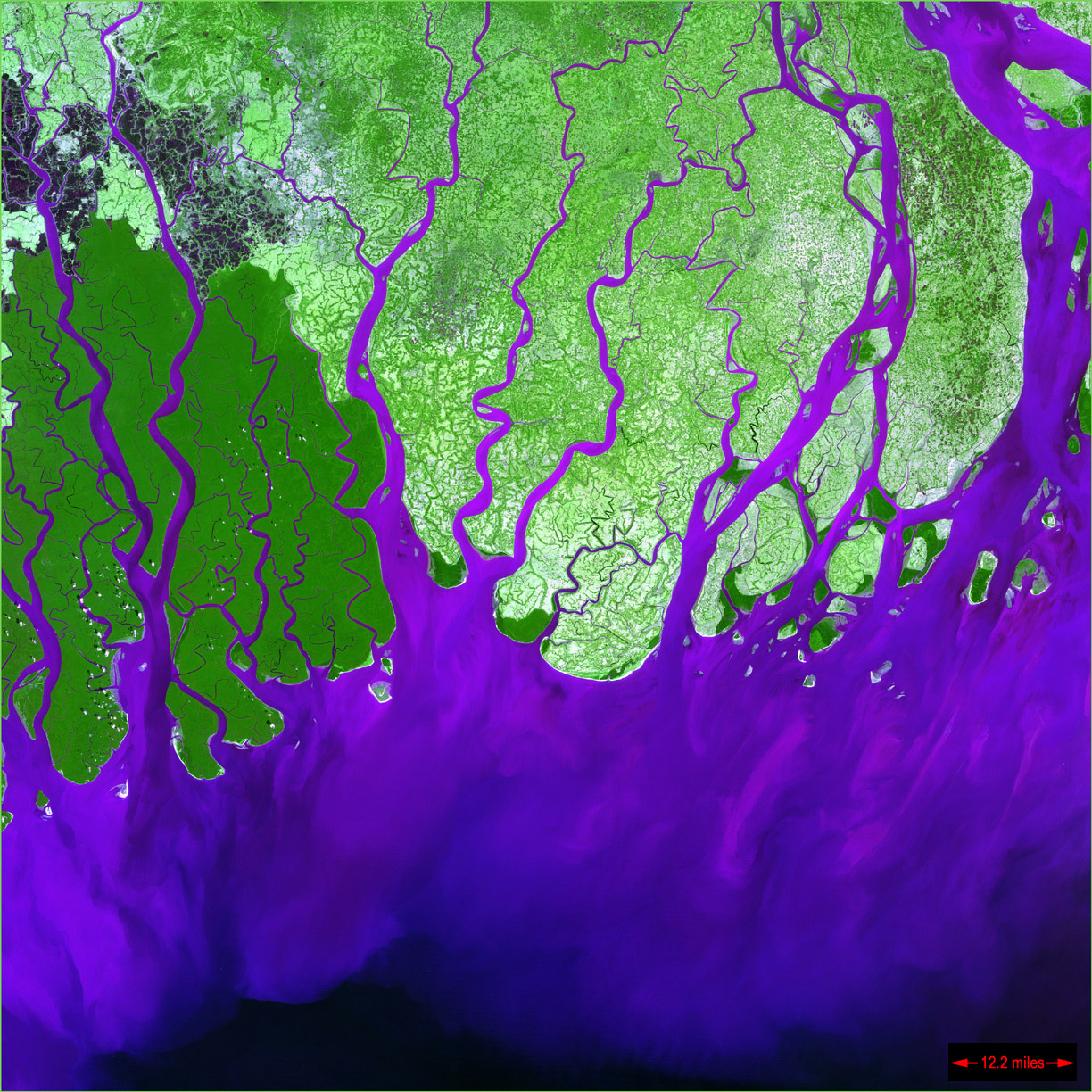
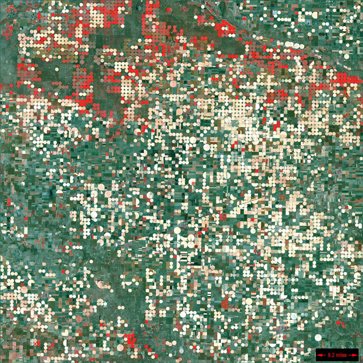
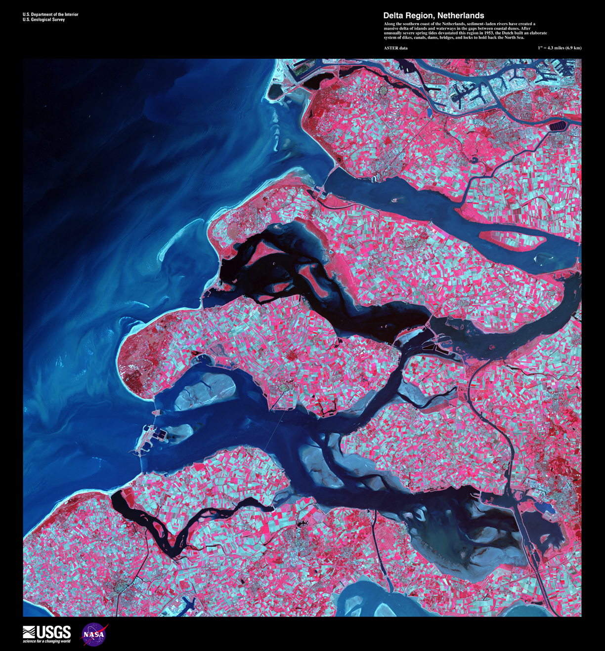
LANDSAT image galleries have a lot to offer...
from NASA: EarthShots and BSRSI(e.g., Amazon forest in the area of the Brazilian states of Tocantins, Maranhao and Para. The image at left as shot in August 1995 and the one at the right shot in May 1997;
Animations: Wyperfeld National Park, Australia (see explanation)
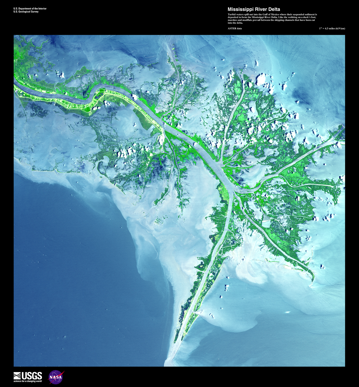
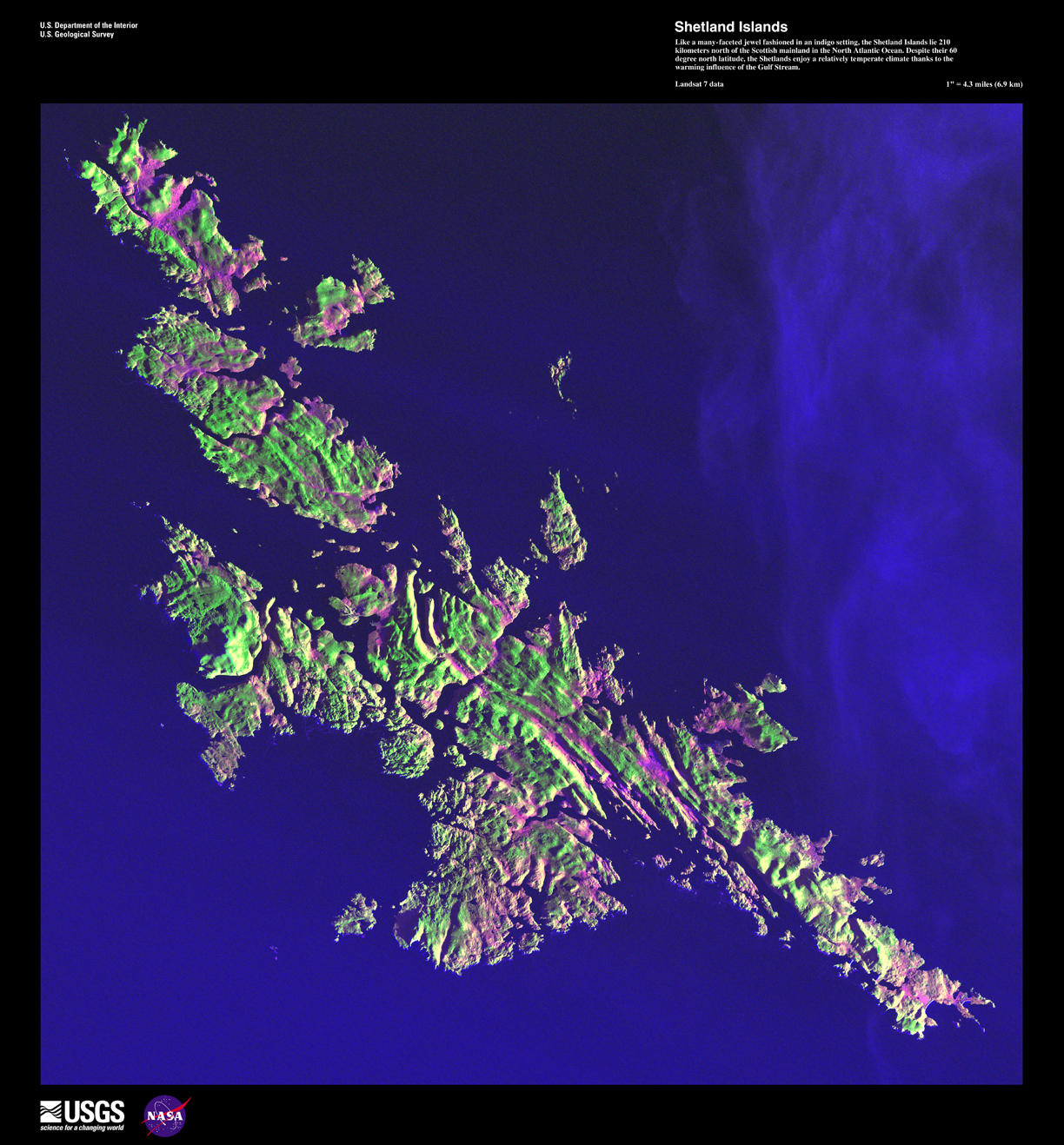
Earth as Art index (Ganges Delta, Garden City KS, Netherlands, Mississippi Delta, Shetland Islands
INTEC Americas (includes IKONOS images)
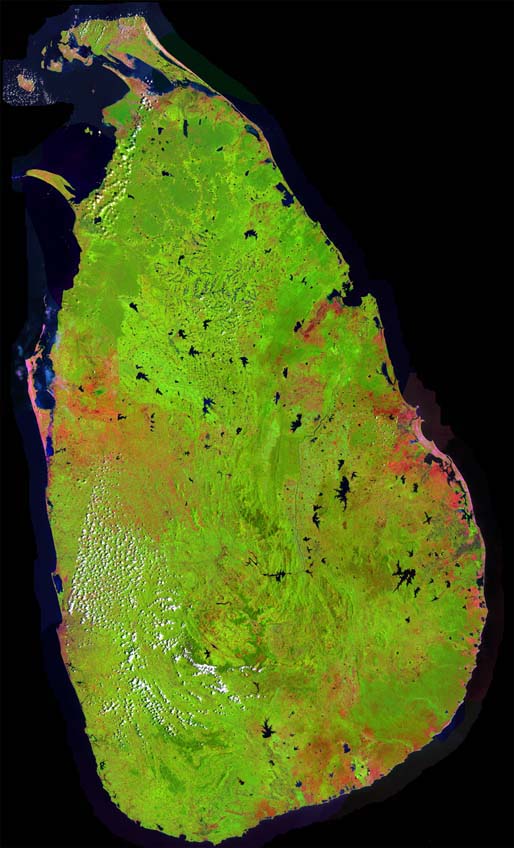
Sri Lanka from landsat.ca
GOES (hurricanes, etc.)
Earth from Space Astronauts' View of the Home Planet
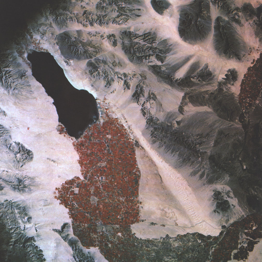
Imperial Valley (compare Apollo 9 photograph, and see full page) See also Environmental Issues of the California-Baja California Border Region by Paul Ganster (Border Environment Research Reports [Number 1 - June 1996])
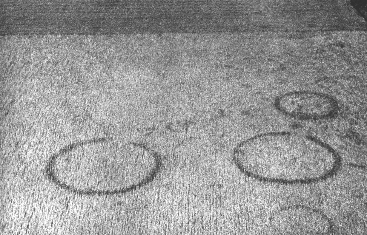
Cropmarks and aerial archaeology (e.g.)
How Do Archaeological Sites ShowCropmarks show as differential growth in arable crops caused by the presence of sub-surface archaeological features..."
Map of Paved Surfaces (detail cached here)
landscape images, scanned and grabbed
This bit of Canadiana from Kate
5 January
Aral Sea:
links from Pimm 2001
? R:/global/aral.mxd --has LandScan, WSI Earth, nitelites
qanats from waterhistory.org
6 January
What is it to "control nature"? Skip reminded me of John McPhee's The Control of Nature, which includes the wonderful Atchafalaya piece (New Yorker 23 February
1987). In a sense, 'human culture' is all about the Control of Nature...
see alsoAUTHOR Reuss, Martin, 1945- TITLE Designing the bayous : the control of water in the Atchafalaya Basin : 1800-1995 IMPRINT Alexandria, Va. : Office of History, U.S. Army Corps of Engineers, 1998. CALL NO. TC424.L8 R48 1998....and Corps of Engineers online GIS (got CGM ActiveX from http://www.ahtd.state.ar.us/road/map.htm) and Louisiana statewide GIS --and explore other cgm mapping apps
7 January
Reading McNeill and McNeill The Human Web, I was led to Historical Atlas of the Twentieth Century (Matthew White's longterm project). Magnificent.
see also World Wide Words (Michael Quinion) --another personal labo(u)r of love.
Joseph McFall's Population: a lively introduction from Population Bulletin ...and found via a lookup in Web of Science, from Joel Cohen's 2003 article in Science...
Some stuff from McPhee's Atchafalaya, and occasioned by reading it:
In southern Louisiana, the bed of the Mississippi River is so far below sea level that a flow of at least a hundred and twenty thousand cubic feet per second is needed to hold back salt water and keep it below New Orleans, which drinks the river. (23)(in the 1950s and 1960s) In human terms, a generation passed with no disastrous floods. The Mississippi River and Tributaries Project --the Corps' total repertory of defenses from Cairo, Illinois, southward-- seemed to have me its design purpose: to confine and conduct the run of the river, to see it safely into the Gulf... "We harnessed it, straightened it, regularized it, shackled it." (26)
When rivers go over their banks, the spreading water immediately slows up, dropping the heavier sediments. The finer the silt, the farther it is scattered, but so much falls close to the river that natural levees rise through time... (32)
The levees of the 1920s were about six times as high as their earliest predecessors, but really no more effective. In a sense, they had been an empirical experiment --in aggregate, 1500 miles of trial and error. But in 1927 the results of the experiment at last came clear. The levees were helping to aggravate the problem they were meant to solve. With walls alone, one could only build an absurdly elevated aqueduct... (42-43)
Under nature's scenario, with many distributaries spreading the floodwaters left and right across the big deltaic plain, virtually the whole region would be covered --with fresh sediment as well as with water. In an average year, some 200 million tons of sediment are in transport in the river. This is where the foreland Rockies go, the western Appalachians. South Louisiana is a very large lump of mountain butter, eight miles thick where it rests upon the continental shelf, half that under New Orleans... It is the nature of unconsolidated sediments to compact, condense, and crustally sink. So the whole deltaic plain, a superhimalaya upside down, is to varying extents subsiding, as it has been for thousands of years. Until about 1900, the river and its distributaries were able to compensate for the subsidence with the amounts of fresh sediment they spread in flood... (57-58)
What was a net gain before 1900 has now been a net loss for nearly 100 years, and the Louisiana we have known... is sinking. Sediments are being kept within the mainline levees and shot into the Gulf at the rate of 365,000 tons a day --shot over the shelf like peas through a peashooter, and lost to the abyssal plain. As waters rise ever higher between levees, the ground behind the levees subsides, with the result that the Mississippi delta plain has become an exaggerated Venice, 200 miles wide --its rivers, its bayous, its artificial canals a trelliswork of water among subsiding lands... (58)
As sediments slide down the continental slope and the river is prevented from building a proper lobe --as the delta plain subsides and is not replenished-- erosion eats into the coastal marshes, and quantities of Louisiana steadily disappear. The net loss is over 50 square miles a year... (62)
Use of remote-sensing satellites to monitor sediment plumes in the Mississippi Bight from USGSMapping the conflict between man and the Mississippi BY SANDY SMITH
Land Loss Animations of Coastal Louisiana (!!!)
Mississippi Delta CONTROLLING A RIVER: THE MISSISSIPPI RIVER DELTAIC PLAIN (Union of Concerned Scientists)
three decades of change in the birdsfoot delta of the Mississippi River and hi-res versions
Mississippi Delta Diversions and Eutrophication
Rivers Seen From Space: The Mississippi River Delta with radar image
Contaminants in the Mississippi River, 1987-92 U.S. GEOLOGICAL SURVEY CIRCULAR 1133 Reston, Virginia, 1995 Edited by Robert H. Meade
8 January
Beyond Blade Runner Urban Control: The Ecology of Fear (Mike Davis) ...and a LOT of very miscellaneous texts including postmodernist, cyberpunk, and marxist, in various languages
"coonass" from Encyclopedia of Cajun Culture
The First Acadians in New Acadia: 1764-1784
Louisiana Folk Regions and Cajun parishes
The Mississippi River and Tributaries Project (US Army Corps of Engineers history) and map files ...e.g., the delta
Putting Cancer Alley on the map
Plaquemines GIS data
14 January
from wordspy.com:
Language always tells long stories if we listen; it's littered with the ways we look at things.consider Murdock's Outline of Cultural Materials as an ontology
�Michael Wood, American academic and writer, The New York Times, May 21, 1995
15 January
Pete Loud's maps including some of Indonesia
South Asia Resource Access including Maldives
Summary terrane, mineral deposit, and metallogenic belt maps of the Russian Far East, Alaska, and the Canadian Cordillera --a cool presentation of FGDC metadata, making it seem almost useful...
On the Petén and Selva Maya:
NASA archaeology pagesstudent project on sustainability (Jill Sourial, UCLA)
BRASS/El Pílar (Anabel Ford) ...see also Out of the past, in the present, and for the future of the Maya Forest (Anabel Ford and Keith Clarke)
Forest and Land Cover Mapping for Monitoring the Meso American Biological Corridor
17 January
Figured out that Thursday's problem with access to \vol8\ was a matter of the mapping not reconnecting at login
Next to begin thinking about: geographies of Birth, Death, Marriage and Migration. There are fresh things to say about all of these, and ways to connect up demographic data with 'human cultures'. The obvious 'birth' one is the infanticide stuff, though there are doubtless others as well. Death stuff might well be epidemiology --the Broad Street Pump, the cancer data... though the tie to 'culture' is a bit more tenuous. Marriage could be interesting, if there were data-rich ways to deal with exogamy/endogamy.
Migration
Geography of Migration by Dr. Satish Davgun, Bemidji StateIMISCOE (International Migration, Integration and Social Cohesion in Europe)
Destination Denmark - migration strategies among "spontaneous" ... (PPT) lisborg-destination-denmark.ppt
'irregular migration' and trafficking in Europe
Cajun stuff:
Cultures of Acadiana A Look at the French, Cajun, Black Creole, and Native American Cultures of LouisianaThe Parishes of Acadiana & Our French Heritage
South Louisiana (Smithsonian)
Fertility rates by parishes and regions, Louisiana ...
Fetal mortality rates by parishes and regions ...
Population of Counties by Decennial Census: 1900 to 1990 for Louisiana (includes FIPS codes)
Louisiana parishes map (produces Census quickfacts by clicking, and links to MORE data --this is a WINNER!)
18 January
A glance at Food Security and Globalization
By C. Ford Runge in The Globalist started me on the track of gathering food-and-agriculture materials again, and I've opened a log on things agricultural as a step toward preparing for the Spring Institute. The immediately interesting question is how to manage this and my other logs most sensibly, so that stuff gets into the right one, and so that none of them gets forgotten...
22 January
I've mostly been carrying on my thinking in other places, including Projects 1 and the other topical files linked on the syllabus, but I think I'll cache a few things here for today's thoughts about projects:
Sean's thoughts on the Hajj: Google search for 'hajj maps' is helpful... but what about statistics? (some false positives... but see the ADS that come up!) ...and Majlis Ugama Islam Singapura (pretty unique as an orderly report)... and Google hajj nigeria and hajj niger and hajj mali ...and Mansa Musa Makes the Hajj (and who's Mansa Musa, I hear you ask...)Megan's megaliths: Google megalithic gis points right to The Megalith Map and some downloads ...which point eventually to GPS Waypoint Datasets --I grabbed greenmen.txt and put it into R:\global\... and see International Institute of Astroarchaeology... and how about "hermeneutics of megalithic space" (you'd have to get the book it's in by ILL)
Jessica: Google search gets UK Appalachian Center GIS Website ...and SAMAB data (see also Coweeta GIS Data Download --some in R:\global\samab\). The same at Southern Appalachian Assessment Online Database?
Matt: Adirondack GIS, and general page. And Adirondack GIS Users Group and some maps and some data links ...and from my friends at St. Lawrence University
23 January
animal health site
Just Another Medical Geography Page, which looks like a real winner...John Snow and the Broad Street Pump, of courseMedical Geography from Leeds
Cancer Mortality Maps & Graphs (National Cancer Institute)
Atlas of United States Mortality
NationalAtlas.gov --download shapefiles (e.g., mortality)
Atlas of Cancer Mortality and Other Causes of Death in Spain. 1978-1992 (maps)
MORTALITY AND MORBIDITY INDICATORS 1995-1996 in the Americas (national data)
Atlas of Stroke Mortality (CDC) --see also Heart Disease Atlases
West Virginia Health Status Atlas
Dartmouth Atlas of Health Care (includes QuickTime lectures by Jack Wennberg, and ArcIMS mapping)
The Broad Street Pump
The Broad Street Pump Outbreak (Judith Summers)On the Mode of Communication of Cholera by John Snow, M.D. London: John Churchill, New Burlington Street, England, 1855 ...and maps
GIS, Health, and Epidemiology: An Annotated Resource Guide (Steven Reader, 1995)
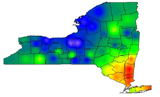
Lyme disease in NY from Lyme Disease In New York State: Spatial Pattern At A Regional Scale (2001) Stephan Glavanakov
And on another subject altogether:
Current Roma migration from the EU Candidate StatesEthnobarometer Programme ...and their Migration and Criminality: the Case of Albanians in Italy by Alison Jamieson and Alessandro Silj Ethnobarometer Programme Working Paper Number 1
Italy to receive 3,000 Moroccan immigrants this year (2/15/2000)
Italy: More and more South Asians
Current Research into Education for Immigrants in Italy (Jonathan Chaloff)
Immigration is a recent phenomenon in Italy. Net migration became positive in 1974 and increased sharply starting in 1990. The foreign presence in Italy, once mostly visitors from other developed countries or Church-related visitors, has become much more similar to the labour migration and settlement in other European countries. In 1998, outgoing remittances surpassed incoming remittances for the first time, and Italy surpassed France to become the number two European country, after Germany, in terms of numbers of new immigrants received.
24 January
Papua: A 'Speaking Freely' piece from Asia Times ("Storm brewing in Papua" by Tom Benedetti of West Papua Action Network) led me to some searches:
Demographics of Papua New Guinea (Wikipedia --and see linked material on West Papua)West Papua Action Ireland
West Papua News Online and Resources for West Papua Independence Campaigns
WESTPAN Canada
Standing Up for West Papua: how Australia profits from an illegal and brutal occupation and what you can do about it
Flash presentation: 'Stop being ignorant about West Papua'
West Papua Niugini/Irian Jaya Homepage 'One People- One Soul' "Kasihi tjinta dari Sobat Papua Barat- Satu bangsa satu djiwa."
Resource exploitation continues as tension mounts (Down to Earth No. 47, November 2000)
The Liberation Army of the Free Papua Movement (TPN/OPM)
The denial of traditional land rights in West Papua Through Indonesia-Act, October 22, 2002 Cultural Survival Quarterly 26.3 - Fall 2002 By Chris Ballard
West Papua: Dutch past, Indonesian present�independent future? John Rumbiak
Case Study: WEST PAPUA'S CULTURAL IDENTITY from BBC World Service
Diseases: A zoonotic disease is a disease which can be transmitted from animals to humans
Zoonotic Diseases: Animal and Food-related Health Risks (WHO) --see EMERGING FOODBORNE DISEASESThe Emergence of Zoonotic Diseases: Understanding the Impact on Animal and Human Health - Workshop Summary National Academies Press 2002 (full text online)
Infectious Animal and Zoonotic Disease Surveillance from Federation of Amerian Scientists
(a lot more moved to an H5N1 log)
25 January
Another 'mysterious disease':
Mysterious disease kills 14 in BangladeshThree out of five children admitted to Dhaka Medical College Hospital(DMCH) over the last three days died on Saturday, raising the death toll to 14 due to this mysterious disease with symptoms including high fever, headache, tendency to vomit, diarrhea and loss of consciousness, the International Center for Diarrhea Diseases Research (ICDDR) told Xinhua on Sunday.Compare Reuters report and Bangladesh Daily StarFour out of the five children in DMCH including the two dead victims all came from a village called Goalanda in southwestern district Rajbari, some 130 km from the capital Dhaka.
(http://news.xinhuanet.com/english/2004-01/25/content_1288164.htm)
29 January
A story in today's NY Times about probable cause of epidemic death of South Asia's vultures
30 January
The intersection of SARS, civets, food supply, medicaments, Cantonese cuisines --indeed, the whole intersection of FOOD and CULTURE...
3 February
"oil transport" regulation Google search
BBC story
4 February
I wonder about using SnipSnap or other wiki/blog apps this spring? What would it TAKE to get one up and running? Explore SnipSnap... talk with Patrick Harris...
Malaria stuff, a starting point anyhow
5 February
Remembering the Herero Rebellion
By Peter Wozny (there could be a whole section on colonial rebellions...)
...The Herero never completely recovered from the conflict and of the around 100,000 that today live in Namibia many live in poverty or work on the farms of white landowners.Herero Genocide and THE HERERO HOLOCAUST? The Disputed History Of The 1904 Genocide (Jeremy Silvester, Werner Hillebrecht & Casper Erichsen) and The Herero War Part 1 and Part 2 (Keith G Emuang)... since Berlin is Namibia�s single largest source of foreign aid, it also sees no need for specific financial compensation to the Herero.
The Namibian government, which is dominated by the Ovambo people, has shown little interest in backing the Herero claims. The German ambassador and a few regional officials attended the small ceremony marking the rebellion on Sunday in the Namibian capital Windhuk, but no government representatives took part.
From Annie:
TITLE Rethinking resistance : revolt and violence in African history /
edited by Jon Abbink, Mirjam de Bruijn & Klaas Van Walraven.
IMPRINT Leiden ; Boston : Brill, 2003.
CALL NO. DT21.5 .R48 2003.
AUTHOR Gewald, Jan-Bart.
TITLE Herero heroes : a socio-political history of the Herero of
Namibia, 1890-1923 / Jan-Bart Gewald.
IMPRINT Oxford [U.K.] : James Currey ; Athens : Ohio University Press,
c1999.
CALL NO. DT1558.H47 G47 1999.
TITLE The colonising camera : photographs in the making of Namibian
history / edited by Wolfram Hartmann, Jeremy Silvester,
Patricia Hayes.
IMPRINT Cape Town : University of Cape Town Press ; Windhoek, Nambia :
Out of Africa ; Athens, Ohio : Ohio University Press, 1998.
CALL NO. DT1523 .C65 1998.
AUTHOR Bridgman, Jon.
TITLE The revolt of the Hereros / Jon M. Bridgman.
IMPRINT Berkeley : University of California Press, c1981.
CALL NO. DT714 .B74.
AUTHOR Drechsler, Horst.
TITLE Let us die fighting : the struggle of the Herero and Nama against
German imperialism (1884-1915) / Horst Drechsler ; [translated
by Bernd Z�llner]
IMPRINT London : Zed Press, c1980.
CALL NO. DT714 .D713.
15 February
This might be useful for Susannah:
The Gaharu Trade in Indonesia: Is It Sustainable?
Tonny Soehartono and Adrian C. Newton
Economic Botany: Vol. 56, No. 3, pp. 271�284.
some synonyms: aloewood, aloeswood, agarwood, Aquilaria spp.
28 February
World Rainforest Movement (just read a 1993 article by Marcus Colchester on Sarawak, and the search for him in Google led to this page)
The Bitter Fruit of Oil PalmProtected Areas. Protected Against Whom?
Certifying the Uncertifiable. FSC Certification of Tree Plantations in Thailand and Brazil
Also: The Resettlement of Indigenous People affected by the Bakun Hydro-Electric Project, Sarawak, Malaysia (The coaltion of concerned NGOs on Bakun (Gabungan) Malaysia)
Orang Asli Archive at Keene State
Halting degradation of natural resources: Is there a Role for Rural Communities?
JEAN-MARIE BALAND and
JEAN-PHILIPPE PLATTEAU
Published by the
Food and Agriculture Organization of the United Nations
1996
8 March
UN study: Think upgrade before buying a new PC
New report finds 1.8 tons of material are used to manufacture desktop PC and monitor (By Martyn Williams, IDG News Service)
According to the study, the manufacturing of one desktop computer and 17-inch CRT (cathode ray tube) monitor requires at least 240 kilograms of fossil fuels, 22 kilograms of chemicals and 1,500 kilograms of water. In terms of weight, the total amount of materials used is about equal to that of a mid-size car.
10 March
Measuring Globalization: Economic Reversals, Forward Momentum, the 2004 A.T. Kearney/FOREIGN POLICY Globalization Index, is recently released. How did I find that out? I did a search for 'globlog' to see if it was in use, and found the blog of Johan Norberg, a Swedish writer "devoted to globalisation and individual liberty. This is my GlobLog, where I share my latest thoughts and explain what I am doing to promote global capitalism."
12 March
R:/global/rockbridge.mxd
22 March
"Culture Jammers"
The Mayhem Is the Message (" 'Culture jammers' use guerrilla media to put 'pimples on the retouched cover of America' ")For years, Nike was the undisputed champion of logo culture, its swoosh an instant symbol of global cool. Today, Phil Knight's Nike is a fading empire, badly hurt by years of "brand damage" as activists and culture jammers fought back against mindfuck marketing and dirty sweatshop labor.
(http://www.blackspotsneaker.org/production.html)sniggle.net ("the culture jammer's encyclopedia")
headmap.org (many links --and see main page: "Headmap examines the social implications and applications of location aware devices, augmented social networks, wearable computers, thinking tools and semantic network interfaces.")
8 April
comments from the Winter 2004 class
This morning I picked up Understanding Global Cultures: metaphorical journeys through 28 nations, clusters of nations, and continents (Martin Gannon GN345.7 .G36 2004) from the New Books shelves. If I was looking for a textbook for 'Human Geography', this would be a very good candidate, though I certainly wouldn't want to march through it lecture by lecture. But its approach is at the same time like my own in its magpie nature, and more orderly in that it has an articulated Idea at its core, the Metaphorical Journey.
A cultural metaphor is any activity, phenomenon, or institution which members of a given culture consider important and with which they identify emotionally and/or cognitively. As such, the metaphor represents the underlying values expressive of the culture itself. (xiii)Gannon's frameworks tend toward the national, and in fact it's often subnational entities that are more interesting to me... but the basic idea is an interesting addition to the range of materials for various specific applications in assorted courses that I might someday teach...
10 May
A topic for a future iteration of Geography of Human Cultures: the fringes of Islam. An interesting problem, in that the chronotope includes zones of active conflict that shift over time, areas of proselytization and growth of the 'umma... and many of them are in areas I've had something to do with. I don't think I've ever seen any very good maps of the "territory" [dar al-Islam] or the landscape(s) of Islam. There are few more timely questions, I'd say. The question is, how to organize the exploration?
Consider Mindanao, Southern Thailand, fighting in Nigeria in the last week [, 2002 story, 2001 report...], conflicts in Indonesia... and of course the events of Indian indpendence and the creation of Pakistan, and Kashmir, and Chechnya, and Bosnia [eHRAF on Bosnian Muslims], and Sinkiang, and Algerian struggles, and the Sudan/Darfur massacres, and... each of these has ethnic as well as religious complexities, and economic and political overtones/implications. The question is, what's really going on? And how can we track it? See Animated Map of Islamic Spain ...and our imminent acquisition of the Encyclopedia of Islam in an online version is another resource...1804 Wilkinson map
11 May
Continuing along those lines, two separate schemes:
Items like Muslims riot in northern Nigeria...Tales that exemplify, illustrate, connect...More than 10,000 people have died in ethnic, religious and sectarian violence in Nigeria since the end of military rule five years ago... Last week, members of the Christian Tarok community attacked the mainly Muslim town of Yelwa in the central Plateau State in a dispute over land and cattle... In 2001, more than 1,000 people died in religious clashes in the Plateau State capital, Jos... The latest violence in Plateau State followed the deaths in February of 48 Christians killed by armed Muslim Fulanis in Yelwa after they had taken refuge in a church.
from a Nigerian site (http://www.onlinenigeria.com/links/plateauadv.asp?blurb=460)
Plateau State is a product of half a century of boundary adjustments arisng on the one hand, from the ambition of the colonial masters to create a province which consisted largely of non-muslims under one Resident, in order to protect the railway line being constructed at that time and guarantee the sustenance of tin mining activities which began in 1902, and the strong desire of the peoples in this area for political self-determination, on the other hand....continues, with Ethnic CompositionIn the formative years of British colonialism in Nigeria, much of Plateau State was part of Bauchi Province. In 1926, Plateau Province, comprising Jos and Pankshin Divisions, was carved out of Bauchi Province. At various times between 1926 and 1976, the boundary of Plateau Province oscillated, paralleling the general trend of political development in the country, as the government of the day acquiesced to the agitation of different ethnic groups to be merged with their kith and kin who are of larger concentrations in other provinces.
When the country was however further divided into nineteen states in 1976, Plateau Province was severed from Benue-Plateau State to become Plateau State. In 1996, the present Nassarawa State was carved out of the western half of Plateau State by the Abacha military regime.
over forty ethno-linouistic groups. No single ethnic group is large enough to claim majority position, but the following are regarded as the major ones: Birom, Angas, Nwangahvul, Tiv, Taroh, Goernai, Tal, Fier, Afizere (Jarawa), Miango, Yourn, Bogghom, Rukuba, Piapung, Kwalla, Montol, Jukun, Challa, Ron-kulere, Pyern, Miship, Mupun, Buji, Kanuri and Nunku. Each ethnic group has its own distinct language, but as in every other state of the federation, English is the official language in Plateau State while Hausa has gained acceptability as a medium of communication.and 'social infrastructure'
Education has been accorded a priority position in the development drive of Plateau State. Christian missionary groups were in the fore front of educational development in the early days of Plateau Province...2,500 displaced in Plateau State violence, says Red Cross
Muslims and Christians had coexisted peacefully in these rural communities for decades, but that all changed in 2001 when a complex mixture of religious issues, arguments over land tenure and politics lead to a spate of tit-for-tat killings and communal attacks... Tens of thousands of people have died in ethnic and religious clashes across Nigeria since President Olusegun Obasanjo came to power in elections in 1999.Squabbles over the distribution of oil revenue in the Niger Delta have frequently led to fatal ethnic clashes. In the north of Nigeria, the decision by 12 largely Muslim states to adopt strict Islamic Sharia Law has led to several large-scale confrontations between Muslims and Christians.
Maps of towns and cities in Nigeria from calle.com
Update: violence in Nigeria from jihadwatch.org ...hardly an 'objective' source, but what is anymore?
All sorts of ethnic complexities viz:
Speakers of Bura (a Chadic language closely related to Marghi) saw themselves traditionally as two ethnic groups, Bura and Pabir, a view not necessarily shared by others. Bura mostly adhered to Christianity or to a local indigenous religion, and a few were Muslims. They lived originally in small, autonomous villages of 100 to 500 persons that and expanded split as the population grew. The Pabir had the same local economy as the Bura, but they were Muslim, they lived in larger (originally walled) villages of 400 to 3,000 with more northerly architectural styles, they resisted splitting up into subgroups, and they recognized a central ruler (emir) in a capital town (Biu). There was a strong movement in the 1980s among many Bura speakers to unite the two groups based on their common language, location, and interests in the wider society. Given long-standing conflicts that separated them as late as 1990, however, their common ethnicity was open to question.See also ethnic relations
And there's Ambon, and other points of contact in Indonesia ("renewed fighting in Indonesia between Muslims and Christians in Ambon, capital of the Maluku Islands, has left at least 36 dead since April 25..." [http://www.csmonitor.com/2004/0511/p07s01-woap.html]) and southern Thailand, and Mindanao ...And shifting to (2), the temporal scheme involving orders of magnitude...
John Man's Atlas of the Year 1000 (CB354 .M36 1999) is provocative in many ways
13 May
I want students to have the experience of doing research with data and tools and electronic presentation media, seeing where an open-ended project leads, and making use of a very broad range of inquiry tools and resources.
Subject matter can be defined by current events, by unique opportunities [like a particular visiting scholar], by serendipitous curiosity. What is less important than how --and the real purpose is to develop skills and perspective on empirical research. Track and interlink and present multiple perspectives and research modalities --journalistic, scholarly, givernmental, anecdotal, literary...
Make Collections, build narrative structures to publicize them... thus, the case of violence between religious communities [e.g., the clashes in Nigeria and elsewhere between "muslims' and 'Christians'] can be made much clearer [and its greater complexities explored] by mapping incidents culled from news reports, building a chronology, seeking out the existing literature on areas in which there's conflict... nobody seems to be doing that, and certainly not as an undergraduate research project.
Is, for instance, Heart of Darkness relevant to Scholarship? How? What connects? This is the essence of interdisciplinary research, INFORMED by disciplinary perspectives and traditions, but not limited.
Google 'ghana muslims', 'gambia muslims', 'cameroon muslims', 'congo muslims' ...and so on. Muslims, Internet Directory by country
The Fulani Cluster (A cluster of 28 Fula groups in 4 major subgroups, located in 16 countries. Latest estimates from the World Evangelization Research Center, UNREACHED PEOPLES PRAYER PROFILES)
PERSECUTION FORCES NIGERIAN CHRISTIANS TO FLEE TO CAMEROON by Obed Minchakpu
MAIDUGURI, Nigeria (Compass) -- Dozens of Nigerian Christian families have fled to Nigeria's neighbor, Cameroon, because of mounting pressure resulting from the implementation of the Islamic legal system, or "sharia," by the Borno state government.The Christians are from the Wuka ethnic group, who are largely found in the villages of Wula, Warabe, Dure, Kughum, and Wala, in the Gwoza area of Borno state. In Dure village alone, more than three dozen Christian families are said to have fled to the northern part of Cameroon.
Another frontier: Kim, Ho-dong, 1954-
Holy war in China : the Muslim rebellion and state in Chinese Central Asia, 1864-1877
Stanford, Calif. : Stanford University Press, 2004.
DS793.S62 K595 2004.
14 May
Who is behind the Maluku violence?
By Marianne Kearney in Jakarta (from Al Jazeera)
(see also Religious gangs clash in Maluku islands By ONGKY ANAKODA, and More Deaths in Continued Violence in Indonesia's Maluku Province by Eriko Uchida , and Ambon / Maluku? (Richard Rowat) --and lots of others: Google search
...fishing for ideas as to why Islam won relatively few converts in Borneo... (Borneo discussion list)
Indonesian chronology e.g., 1400 Aceh converts to Islam; 1414 Paramesvara converts to Islam, and takes the name Iskandar Syah, after marrying the daughter of the Sultan of Pasai. Melaka is now an Islamic sultanate. (The Islamic religion had been common among traders in Sumatra and Java for some time. The Singhasari and Majapahit kingdoms probably had a few Muslims involved in their courts. Large-scale conversions to Islam began when local kings adopted the new religion. Aceh and Melaka were among the first. Most of Java did not become Muslims until the early 1500s.) See Notes on Islam in Modern Indonesia
Islam in the Philippines from Country Studies; see also Islam and Muslims in Philippines and Islam in the Southern Philippines by Isabelle Vloeberghs
8 July
Thinking about a possible next iteration in Winter 2005, there are some GLOBAL articles in recent issues of Nature that could be effective starting places:
Genesis of a highly pathogenic and potentially pandemic H5N1 influenza virus in eastern Asia (K. S. LI et al. Nature 430, 209 - 213 (08 July 2004); doi:10.1038/nature02746 )The challenge of emerging and re-emerging infectious diseases (DAVID M. MORENS, GREGORY K. FOLKERS & ANTHONY S. FAUCI Nature 430, 242 - 249 (08 July 2004); doi:10.1038/nature02759 )
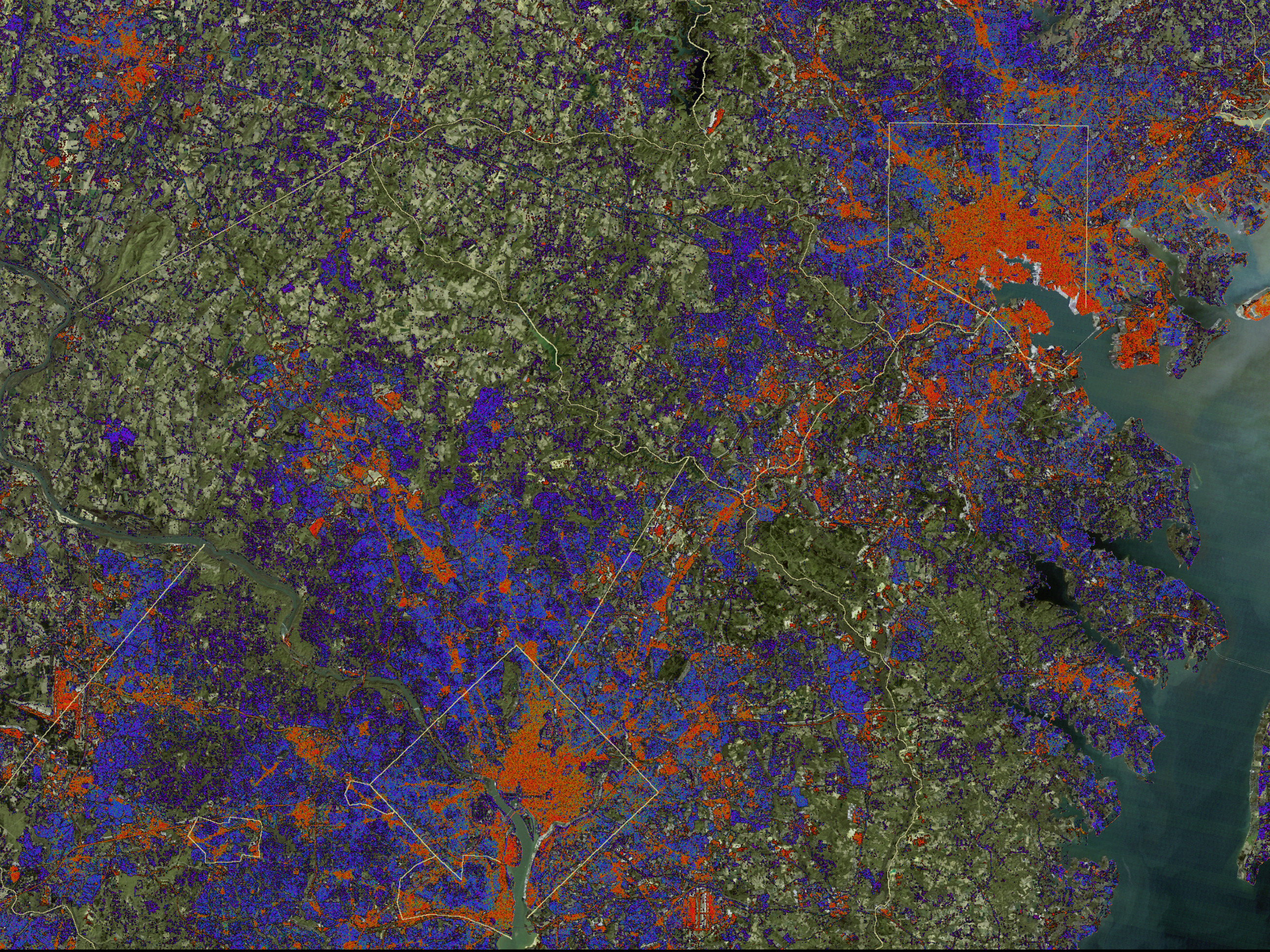
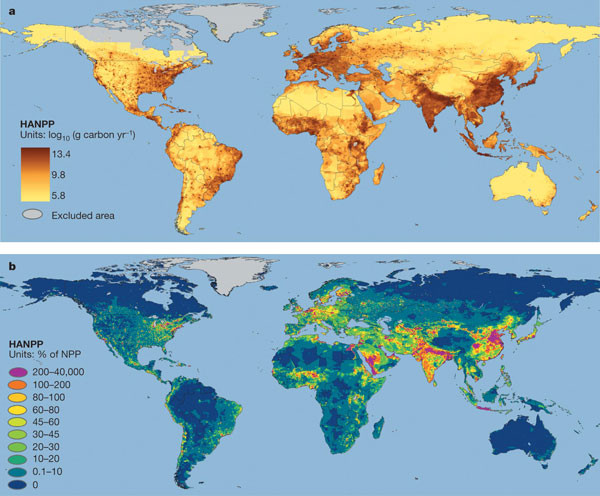
Global patterns in human consumption of net primary production MARC L. IMHOFF et al. Nature 429, 870 - 873 (24 June 2004); doi:10.1038/nature02619) (see the map images --and see hi-res versions)