The opportunity to design a library to fit the times and the problems, and to build it with present and future information technologies in mind (instead of reconfiguring legacy spaces and systems) is an interesting challenge that few get a chance at. When I was in library school a decade ago, I had a class in Science Librarianship that included an assignment to design a reference collection for a specific setting: Mount Washington Observatory, or a regional poison hotline, etc. At the time, electronic resources were just beginning to be salient in collection development and in reference work, so the emphasis was on identifying paper resources for the use of people who were not librarians, but had specifiable 'information needs'.
The task of designing and building a library to support the integrative teaching and learning of the Biosphere 2 educational programs shares some of the requirements and problems of the library school assignment --developing a focused collection to anticipate what users will seek answers to-- but differs
Design for Access, not Storage
Tools and possibilities for access are advancing rapidly and have great
potential to change the ways in which information is used in teaching and
learning. What will not serve your needs is a 'library' defined
as a room with 5000 books, no matter how carefully those 5000 are selected.
Books are surely essential, but they are decorative if they don't actively
serve the needs of information-seekers. The common observation that undergraduates
use the Web as their primary tool for research (and that they are uncritical
and lack 'research skills') implies necessity for education and continuing
support, especially for the tools and resources with real power. Access
to Columbia's electronic resources is a fantastic advantage, but they are
not
self-supporting; realizing the potentials of these (and turning them into
something actually useful to Biosphere 2's programs) will require professional
assistance, which can and should be built as an explicit part of integrative
teaching. It is not clear to me whether the Librarian (whom I gather is
funded for one year, and will be sent out from the Columbia Libraries)
will begin (or develop on site) as an information specialist for the use
of Biosphere 2 staff and students, or is expected to set up a free-standing
library and then retreat to NYC, leaving staff and students to negotiate
the jungles of information on their own.
The Role of the Librarian
Electronic resources like citation indexes and archives of full text
change teaching and learning in ways we're just beginning to grasp. Thus,
JSTOR offers the entire archive of such journals as Science, Ecology,
and Population Studies, searchable by keyword; Science Citation Index allows
exploration of more than 25 years of bibliographic interlinkage in more
than 5,000 journals; and SciFinder Scholar enables easy searching of the
last 34 years of chemical (and related) literature. These potentials certainly
fit with the concerns of Biosphere 2 courses, but successful integration
will require the active participation of a librarian who understands both
the problems of instructors and the possibilities of the full array
of information resources, and is committed to teaching the skills to make
effective use of these resources. To realize the potential, the librarian
ought
to be a full participant in the integrated teaching program, and should
also be an adventurer in other realms of digital information, including
images and spatial data.
Incorporating Geographic Information Systems (GIS)
It is one thing to look at maps and images, and entirely another to
learn to analyze patterns in space. Among the information
media which need to be integrated into the library's purview is GIS, which
exemplifies both the promise and the support problem of the global digital
library: users have access to vastly increased data and unprecedented perspectives,
which transform what they can study, represent, visualize, and know. Few
libraries are adept at serving and supporting GIS data, but Biosphere 2
is already in contact with one of the leaders in this area, at University
of Arizona, and it wouldn't be difficult to put together the relevant
datasets to support study of the past and present of the Tucson region.
Thus, the Pima
County Land Information System datasets, Digital Elevation Model (DEM),
and Digital Ortho Quarter Quads (DOQQs) for the area of Biosphere 2, in
combination with data collected with GPS receivers and analysis done with
ESRI's ArcView GIS software, would provide the basis for a growing archive
of spatially-referenced data on the immediate environment. LANDSAT and
other satellite imagery would facilitate broader analysis of ecosystem
characteristics and changes. The Advanced
Resource Technology Group at University of Arizona is very active in
these areas. Similar coverage for field study areas in Mexico and elsewhere
in Arizona would greatly enhance the perspective you can offer students,
and hands-on experience with analyzing spatial data would broaden student
skills dramatically. Managing such data resources and analytical power
(and teaching their use) requires training and interest beyond that of
most librarians, but it's just the sort of information-management challenge
a Biosphere 2 librarian should welcome.
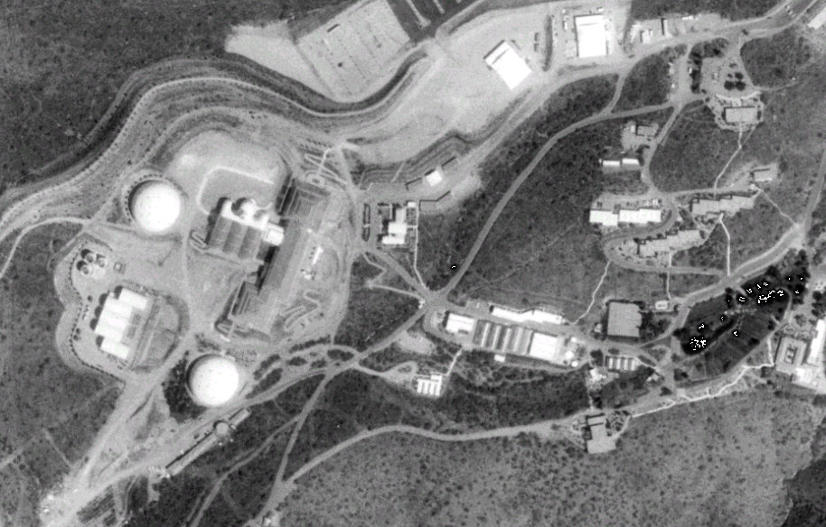
Here's a piece of a DOQQ from 1992 (downloaded via University of Arizona, and brought into ArcView), showing Biosphere 2:
ArcView (which is pretty close to being an industry standard) operates in the Windows environment, requires some fairly elaborate tending in networked settings, and (because of its power) has a rather steep learning curve. Global Positioning Systems (GPS) receivers facilitate the collection of georeferenced data, and it's entirely possible to connect GPS and GIS to support field data gathering. ESRI's ArcPad (a small-scale version of ArcView) runs on (many, probably not all) Windows CE handhelds, but not on Palm Pilots.
ESRI is very open-handed in supporting educational uses, and I see that Columbia has an ESRI site license (see Columbia Earth Institute ), which may also be applicable to the Biosphere 2 program. I also found Metropolitan East Coast Assessment as an example of a GIS-based Columbia program, and CIESIN and Lamont-Doherty make extensive use of ESRI products.
I'd be glad to talk further about any of the above issues.
Hugh Blackmer
Science Librarian
Washington & Lee University
blackmerh@wlu.edu